2024-09-22 21:30:03
BIRMINGHAM, Ala. (WBRC) – Happy Sunday! Astronomical Fall officially arrives today at 7:43 a.m. CDT. Sunrise occurs at 6:35 a.m. CDT with sunset at 6:43 a.m. CDT. Fall is officially here, but the weather continues to feel more like summertime. Temperatures this morning are starting out in the upper 60s and lower 70s. Our average low for September 22 is 64°F, so we are several degrees above average. We are looking at another day with a mostly sunny to partly cloudy sky. We could see some extra cloud cover this afternoon, but I think we will remain dry and hot. High temperatures are forecast to heat up into the lower 90s this afternoon with westerly winds at 5-10 mph. If you have any evening plans, we should remain dry with temperatures cooling into the low to mid 80s by 7 p.m. CDT.

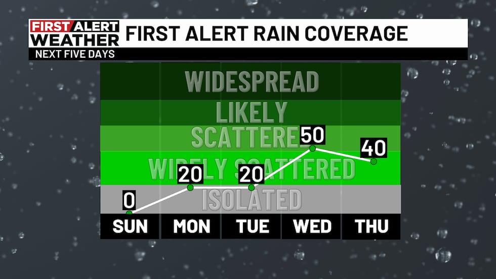
Summer-like pattern Monday and Tuesday: It looks like the summertime heat will continue for the first half of the week. Morning temperatures will likely start out in the lower 70s Monday and Tuesday morning. Upper 60s can’t be ruled out for areas north of I-20. The change in the forecast for tomorrow and Tuesday is that there’s an outside chance for an isolated shower or thunderstorm. Temperatures will remain five to eight degrees above average with highs in the lower 90s. Our average high for this time of the year is 84°F. I think most of us will remain dry, but a few spots could see a brief downpour with some lightning.
Summer-like pattern Monday and Tuesday: It looks like the summertime heat will continue for the first half of the week. Morning temperatures will likely start out in the lower 70s Monday and Tuesday morning. Upper 60s can’t be ruled out for areas north of I-20. The change in the forecast for tomorrow and Tuesday is that there’s an outside chance for an isolated shower or thunderstorm. Temperatures will remain five to eight degrees above average with highs in the lower 90s. Our average high for this time of the year is 84°F. I think most of us will remain dry, but a few spots could see a brief downpour with some lightning.
Tropical Storm likely to develop in the Gulf: Our long-range models continue to show strong support of a tropical storm or hurricane developing in the Gulf of Mexico this week. A disturbance is developing right now in the western Caribbean. The National Hurricane Center is giving it a 70% chance to form into a tropical depression or storm over the next seven days. Some of our guidance is starting to show a faster moving storm in the eastern half of the Gulf of Mexico by the middle part of the week. It is possible we could see a hurricane slam into the Florida Panhandle or the Florida Peninsula Thursday into Friday. Since the storm has yet to develop, the models will continue to show different solutions on intensity and track this week. We won’t have high confidence on this forecast until something forms. Anyone who lives along the Gulf Coast from Louisiana all the way to the western coast of the Florida Peninsula should pay close attention to the National Hurricane Center’s forecasts. This storm has a chance to be large, so that means storm surge and heavy rain/flooding will be likely on the eastern side of the storm.
The influence of the cold front and this tropical low could also play a role in our rain chances by the end of the week and going into the weekend. We will likely see cooler temperatures Thursday and Friday with highs in the lower 80s. Scattered showers will be possible on both days. If this system develops faster and moves quickly to the northeast, we could see drier conditions over the weekend. If the tropical low merges with the cold front, we could see a lingering low spin across the Southeast providing us rain chances over the weekend. We have different solutions with not a lot of answers. It remains too early to know if next Saturday will be wet for the big game in Tuscaloosa as the Crimson Tide take on the Georgia Bulldogs. I’m leaning towards a drier setup for the weekend, but that will all depend on how this tropical low develops. Stay tuned for updates and plan for changes in the forecast as we get the latest information!
Tropical Outlook: We are also watching two other systems in the Central and Eastern Atlantic. An area of low pressure located several hundred miles southeast of Bermuda is producing storms north of the center. There’s a small window for this system to briefly become a tropical depression, but the National Hurricane Center continues to show a 20% (low) chance for development over the next 48 hours. A tropical wave is likely to move off the coast of Africa this week. Odds of development is up to 40% over the next seven days. Long-range models do support this wave becoming a named storm, but it remains too early to know if it will impact anyone. It’ll be something to watch. I think the Atlantic could remain active going into the first half of October. Hurricane season officially ends on December 1.
Make sure you download the WBRC First Alert Weather app on Android and Apple devices for the latest weather information.
Get news alerts in the Apple App Store and Google Play Store or subscribe to our email newsletter here.
Copyright 2024 WBRC. All rights reserved.


