2024-08-12 15:20:02
BIRMINGHAM, Ala. (WBRC) – The Perseid meteor shower peaks early Monday morning. You could see 50 to 100 shooting stars per hour! Just look anywhere in the night sky between midnight and 5:30 a.m. CDT to catch the shower. It is best to view shooting stars away from city lights. Expect some passing clouds at times with temperatures cooling into the 60s. If you somehow capture the shooting stars via video or pictures, feel free to submit them through the WBRC First Alert Weather App. We may show your pictures on WBRC and on social media.
Beautiful Monday: We will likely wake up tomorrow morning with plenty of sunshine with temperatures in the mid to upper 60s. It should feel great as the kids wait at the bus stop tomorrow morning. We will enjoy one more day of comfortable humidity levels. We will likely see a mostly sunny to partly cloudy sky tomorrow afternoon with high temperatures close to average in the lower 90s. Winds will continue from the north at 5-10 mph. Enjoy the lower humidity tomorrow because the mugginess will slowly increase Tuesday into Wednesday.

Humidity returns next week: It looks like the humidity will slowly return Tuesday into Wednesday. Temperatures will trend a little warmer Tuesday with lows in the lower 70s and highs in the mid 90s. Humidity will likely return by Wednesday, which means our morning temperatures will trend above average with most of us waking up into the mid 70s Wednesday morning. With increasing humidity levels by the middle part of next week, the heat index may climb into the triple digits. It will be important for those who work outside to remain hydrated and take breaks as the heat levels climb for the second half of the week. High temperatures this upcoming week will likely remain in the low to mid 90s.

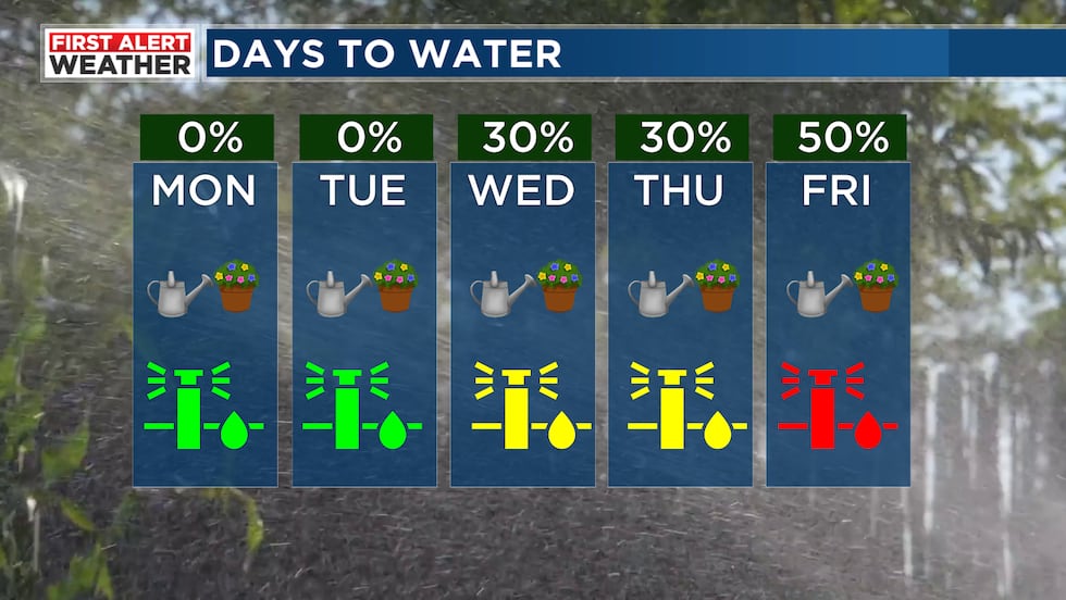
Next Big Thing: If you are hoping for some rain, it looks like we’ll see scattered storms return by the middle of this upcoming week. Northwest flow will likely develop Wednesday and continue into next weekend. It means a series of disturbances could develop to our north and push to the southeast into parts of Mississippi, Alabama, and Georgia. Scattered storms will be possible each day. A strong or severe storm can’t be ruled out in this setup. Heavy rain, strong winds, and frequent lightning will be the main threat. Temperatures will likely remain in the low to mid 90s with overnight lows in the mid 70s. Not everyone will see rain for the second half of the week. Storm chances look scattered Wednesday but become more isolated Thursday afternoon. Additional rounds of scattered storms will be possible Friday through next Sunday.

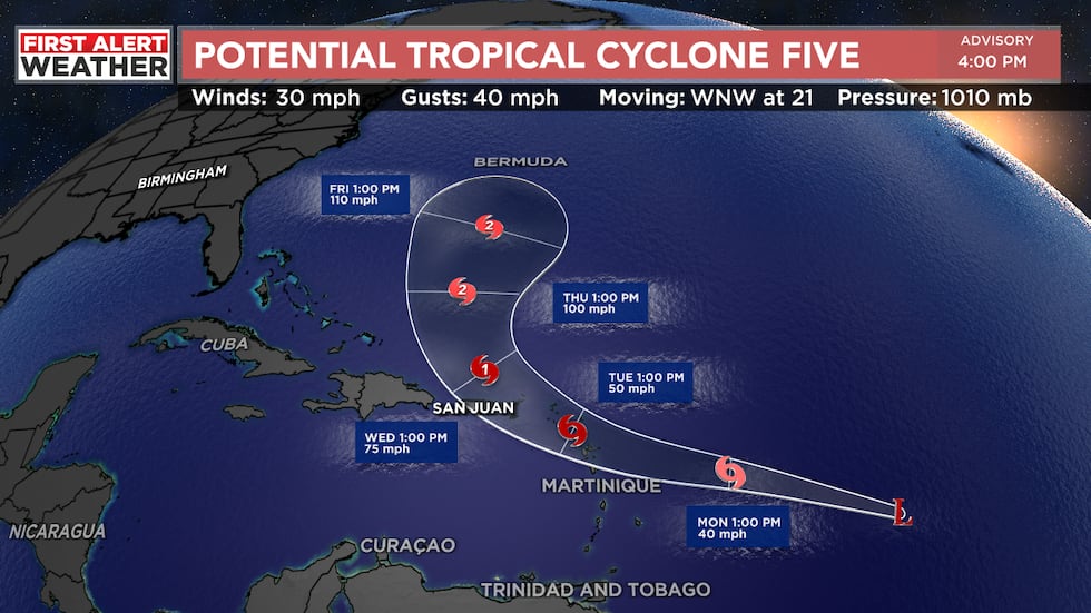
Tropical Update: The National Hurricane Center has now designated the Atlantic disturbance as “Potential Tropical Cyclone Five,” meaning this will likely become Tropical Storm Ernesto within the next 24 hours or so. Soon-to-be Ernesto could impact the Lesser Antilles and Puerto Rico Tuesday through Thursday. There’s a decent chance this storm could become a hurricane once emerging from Puerto Rico. I think this system will likely remain in the Atlantic. Long-range models show a trough picking this storm up and hopefully curving this storm out into the northern Atlantic Ocean. It remains too early to know if it will impact the East Coast of the United States. The entire East Coast will need to watch this storm carefully. Odds of this storm moving into the Gulf of Mexico remains highly unlikely. The rest of the Atlantic remains quiet. Hurricane season normally ramps up now and peaks in the middle of September. Hurricane season officially ends on November 30th.
Get news alerts in the Apple App Store and Google Play Store or subscribe to our email newsletter here.
Copyright 2024 WBRC. All rights reserved.


