2024-11-09 13:55:03
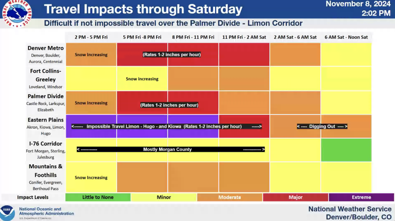
DENVER — Up to 2 inches per hour snowfall rates are expected in Denver through late Friday evening bringing major travel impacts in the metro and especially across the Palmer Divide and eastern plains.
As the snow has continued to pile up Friday morning and afternoon, more widespread snow is expected in Denver starting at around 5 p.m., according to the National Weather Service (NWS) in Boulder.
Denver’s first official snow of the season has already surpassed the normal monthly total for all of November as the metro’s reporting station at Denver International Airport recorded 8.9 inches of accumulation so far, as another big dumping of snow is on the way.
The November snowfall average for Denver is 7.3 inches.
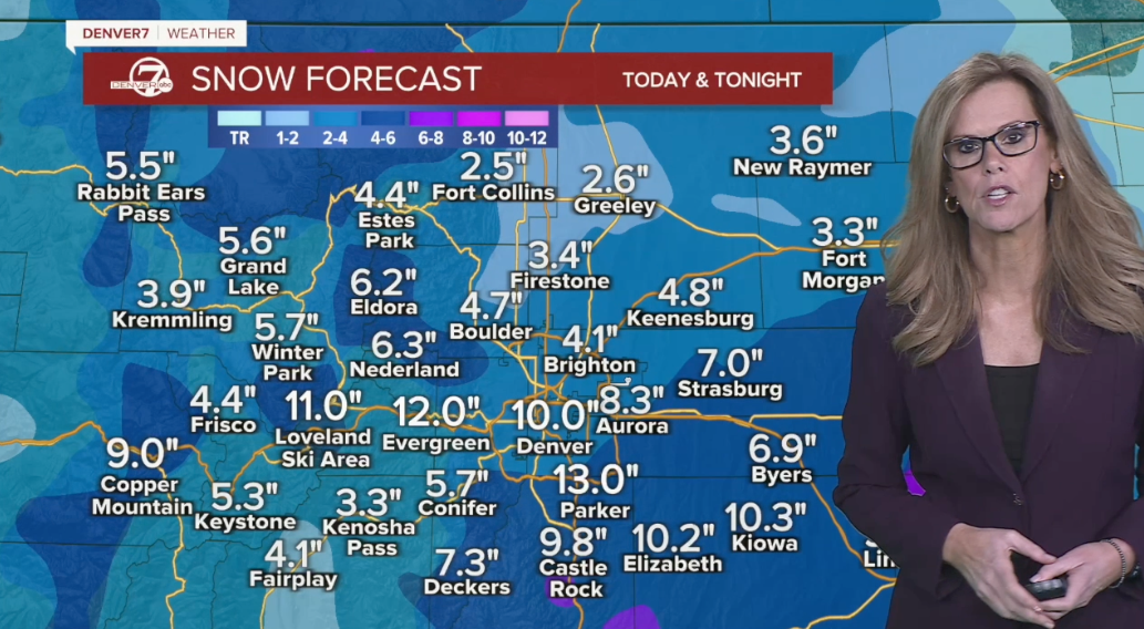
Another foot could be added to Denver’s snow totals by the time this storm system moves out on Saturday.
“Heavy snow will continue through the overnight hours into Saturday as roads are closed on the plains. The snow will finally end Saturday afternoon,” said Denver7 meteorologist Stacey Donaldson. “Here in Denver, we’re looking at between 6 and 12 inches of snow with winter storm warnings in effect,” added Donaldson.

NWS Boulder
The Friday evening commute is expected to be dicey in Denver as snowfall totals also pile up, especially across eastern Colorado. Donaldson said 21.3 inches of snow has already dumped on Limon with 20 inches reported in Elizabeth and 14 inches in Parker.
“It’s definitely east of I-25 where we’ve seen the highest amounts of snowfall,” said Donaldson.
Weather forecasters said to expect continuous waves of snow all day and evening on Friday in Denver before the storm’s last gasp comes around noon or slightly later on Saturday.
Denver7 Weather
This epic snowstorm could be Denver’s biggest in November in decades
As for Denver’s snow totals, an additional 3 to 8 inches are possible for the remainder of Friday before Saturday’s snowfall will bring between 1 and 3 inches before skies begin to clear out Saturday afternoon.
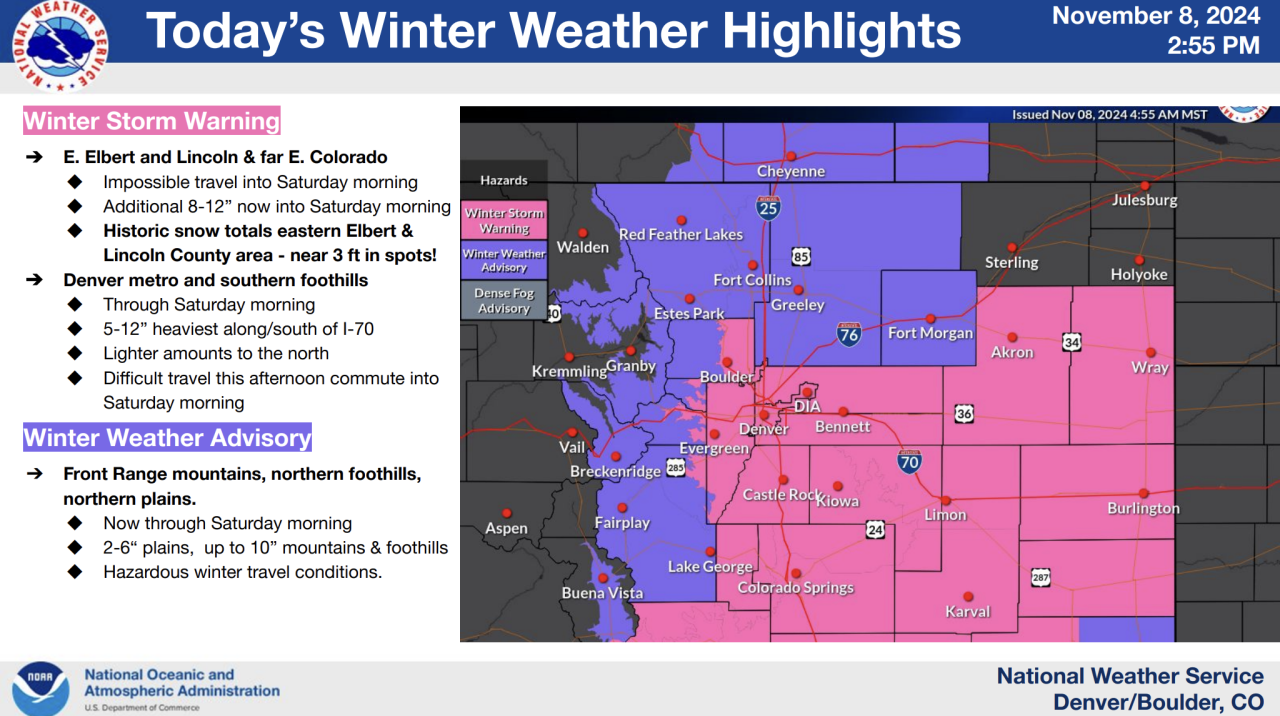
The entire Denver metro area, most of the I-25 corridor, the Palmer Divide and eastern plains are under a winter storm warning where double-digit snowfall accumulations are expected with forecasters and law enforcement agencies discouraging travel in areas slammed hardest by the winter storm.
“If you must travel, take a winter storm kit along with you, including such items as tire chains, booster cables, flashlight, shovel, blankets and extra clothing. Also take water, a first aid kit, and anything else that would help you survive in case you become stranded,” wrote the National Weather Service (NWS) in Boulder.
To view the snowfall totals infographic in full screen mode, click this link.
Snowfall rates could reach between 1 and 2 inches per hour across Denver between 5 p.m. Friday into the overnight hours, said the NWS, where major travel impacts are expected. “Impossible” travel conditions are expected near Limon, Hugo and Kiowa from 2 p.m. Friday through around midnight, added the NWS.
The Palmer Divide is expected to see periods of 2-inch snowfall rates between noon and midnight.
The NWS said to expect “historic” snow totals in Eastern Elbert and Lincoln Counties – up to 3 feet in spots – as Lincoln County law enforcement on Thursday told Denver7 conditions were “dangerous” and the heavy, continuous snow were hampering efforts to get to stranded motorists.
“We’re finding people on county roads that have no business being that far off the highway. So we don’t know who we’re missing, because some of these drifts on these county roads are 7, 8 to 10-foot deep,” Lincoln County Sheriff Tom Nestor told Denver7. “I’ve not seen a storm like this in many, many years. I’m going on 36 years at the sheriff’s office and we’re having a lot of trouble getting around. We just can’t get people out.”
The message from Lincoln County officials was to “just stay home.”
Areas north of I-76 will see less snow but there will be travel impacts, said the NWS.

NWS Boulder
A winter weather advisory is in effect through noon on Saturday for Colorado’s far northern counties and the north and central mountain ranges. Greeley and Fort Morgan are included in the winter weather advisory where between 2 and 8 inches of snow is possible, according to the NWS.
Fort Collins’ snow totals is forecast to be between 2 and 4 inches.
“By tomorrow afternoon, skies start to clear out. If you’re headed up to the mountains, I’m not so sure that Saturday morning drive is going to be great. We may see some closures out west on I-70,” said Hidalgo. “If you’re headed up Friday, coming back Sunday is going to be a lot better.”

Denver7
This storm will likely go do down as the biggest November storm Denver has seen in nearly 3 decades. Denver7’s Grant said the last major November storm was a two-day whopper on November 13-14, 1994. 12.1 inches of snowfall stacked up at Stapleton Airport with 16.9 inches of snow overall that month.
Ahead of the storm, Governor Jared Polis verbally-declared a disaster emergency and activated the Colorado National Guard to assist with the storm response.
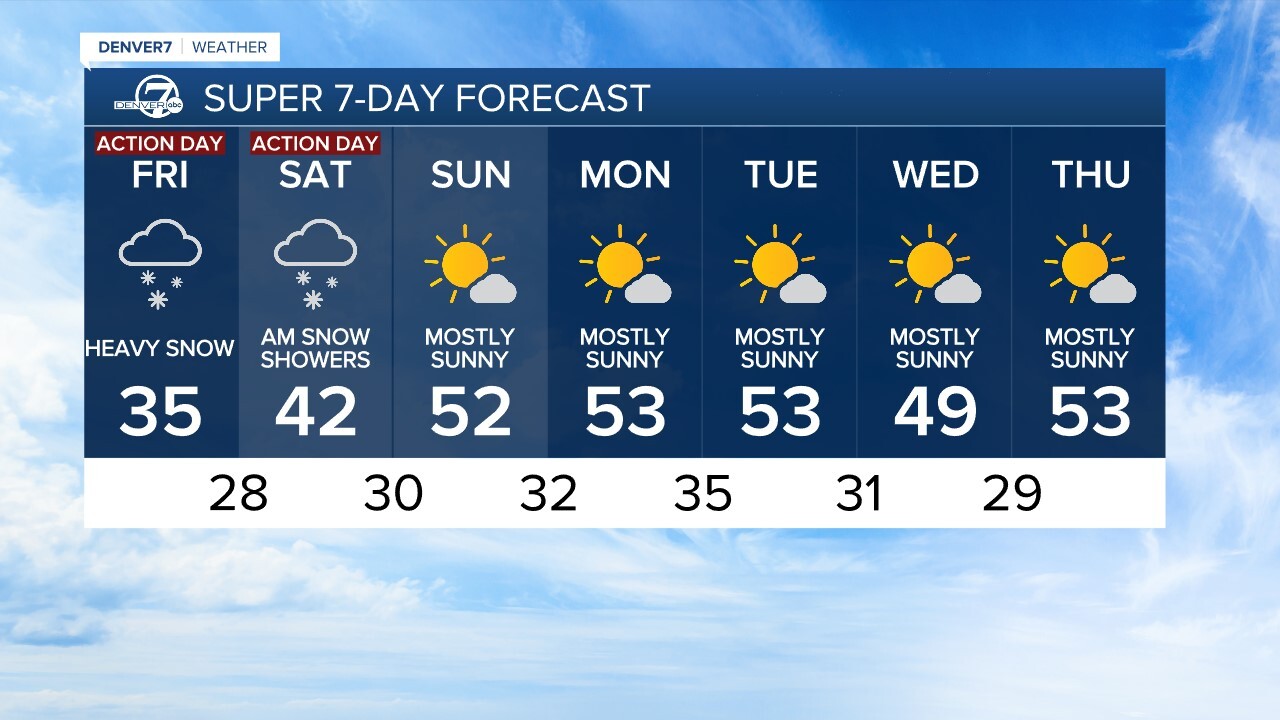
If you’re looking for a break from the snow, starting Sunday – temps rebound into the 50s with plenty of sunshine to get the melting started.
Denver’s 7-day forecast shows mostly sunny skies and highs in the 50s starting Sunday through next Thursday.

Denver7

DENVER WEATHER LINKS: Hourly forecast | Radars | Traffic | Weather Page | 24/7 Weather Stream
Click here to watch the Denver7 live weather stream.


