2024-10-04 19:55:04
Editor’s Note: This story was published Thursday morning. Click here to track the latest developments with Hurricane Kirk.
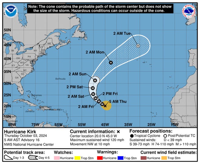
Hurricane Kirk continues to strengthen in the Atlantic Ocean and could bring large swells to the east coast of the United States by Sunday, according to the National Hurricane Center.
The hurricane center said in an advisory Thursday morning Kirk was located about 1,130 miles east of the Northern Leeward Islands and is forecast to continue moving northwest through early Friday. A turn toward the north and north-northeast at a faster forward speed is forecast over the weekend.
With maximum sustained winds near 125 mph, Kirk was a Category 3 hurricane as of Thursday morning and is forecast to continue strengthening over the next day or so, according to the NHC.
Although Kirk is forecast to turn north and stay over the open Atlantic, the NHC said the storm could cause “life-threatening surf and rip current conditions” that could reach portions of the Leeward Islands on Friday, Bermuda and the Greater Antilles on Saturday, and the east coast of the United States and the Bahamas on Sunday.
The hurricane center is also keeping a close eye on Tropical Storm Leslie, which continues to strengthen.
October hurricane forecast:Brace for the ‘return of big hurricanes’

Hurricane Kirk path tracker
Hurricane Kirk spaghetti models
Illustrations include an array of forecast tools and models, and not all are created equal. The hurricane center uses only the top four or five highest performing models to help make its forecasts.
If path tracker and spaghetti model are not displaying on your screen, you can view them here.
NHC also keeping tabs on system in Gulf of Mexico
The NHC is also keeping an eye on “a broad area of low pressure” that is likely to develop over the Gulf of Mexico late this weekend or early next week.
A surface trough is currently producing disorganized showers and thunderstorms over portions of the Gulf of Mexico, however subsequent tropical or subtropical development of this system could be limited by its potential interaction with a frontal boundary, the NHC said Thursday morning.
“Regardless of development, locally heavy rains could occur over portions of Mexico during the next few days and over portions of the Florida Peninsula next week,” the NHC said.
Atlantic storm tracker
Gabe Hauari is a national trending news reporter at USA TODAY. You can follow him on X @GabeHauari or email him at Gd******@*****tt.com.


