2024-08-02 20:45:02
Tropical storm watches or warnings could be issued for parts of Florida as early as tonight as Invest 97L is expected to move over Cuba and into the Florida straights Friday night or early Saturday.
The National Hurricane Center elevated the chance the well-organized tropical wave forms within the next 48 hours to 60% and increased the chance it forms over the next seven days to 90%, in its latest advisory.
Florida Gov. Ron DeSantis Thursday declared a state of emergency for 54 of Florida’s 67 counties ahead of the storm, including Escambia and Santa Rosa counties.
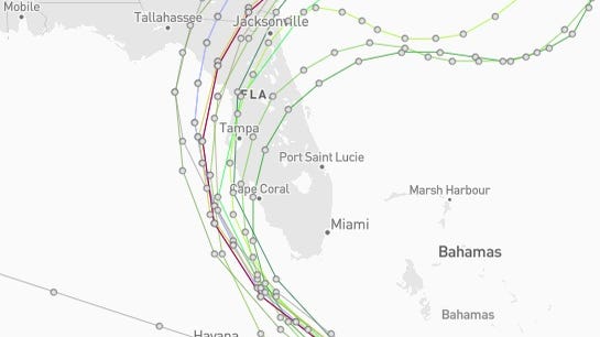
AccuWeather published a potential path for Invest 97L that would have the eye of Invest 97L running along the northern coast of Cuba and coming out into the Florida Straights Saturday morning.
From there, the potential path would have the storm hugging Florida’s west coast, reaching the elbow of Florida Big Bend Sunday night. By Monday night, AccuWeather predicts the storm will have passed through Florida and into the southeastern tip of Georgia.
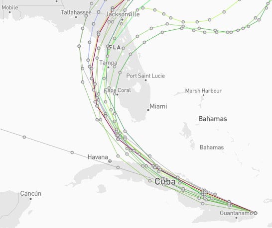
“The latest models show it going into the eastern Gulf and then exploding there,” said AccuWeather Lead Long-Range Expert Paul Pastelok. “Residents from Louisiana to Florida’s West Coast have to be ready in case it rapidly intensifies.”
If sustained winds reach 39 mph, it would become Tropical Storm Debby, the fourth named storm of the 2024 Atlantic hurricane season.
Latest updates on Invest 97L
Invest 97L is currently producing poorly organized showers and thunderstorms over eastern Cuba, Hispaniola, the southeastern Bahamas and Jamaica.
The wave is expected to move near or over Cuba throughout the day and emerge over the Straights of Florida tonight or Saturday, according to the NHC’s 8 a.m. advisory.
Invest 97L is likely to form into a tropical depression this weekend over the Straights of Florida or the eastern Gulf of Mexico near the Florida Peninsula.
NHC expects that tropical storm watches or warnings could be required for portions of Florida later today.
Heavy rains could cause areas of flash flooding across parts of Florida, as well as Cuba and the Bahamas, through the weekend.
A NOAA Hurricane Hunter aircraft is scheduled to investigate the system later today.
- Formation chance through 48 hours: Medium, 60%
- Formation chance through 7 days: High, 90%
Spaghetti models: Latest models on where Invest 97L could go as it moves toward Florida
What’s expected to happen with Invest 97L over the next week?
The guiding winds that are steering Invest 97L west-northwest this week are expected to weaken, according to AccuWeather. If the system does stall, it could bring days of downpours to parts of the southeast United States, especially in coastal areas.
The likelihood of that scenario occurring will depend on the intensity and track of the tropical storm after it passes near Florida over the weekend.
The worst-case scenario is that Invest 97L stalls over the Southeast and produces feet rather than inches of rain in some areas, resulting in major flooding, according to AccuWeather.
Will Invest 97L impact Florida?
“Downpours and gusty thunderstorms will spread westward across Cuba and the western islands of the Bahamas on Friday before spreading over the Florida Keys and the southern part of the Florida Peninsula on Saturday.
“Along with the potential for urban flooding will be the risk of waterspouts and hazards for beach and boating interests, at the very least,” AccuWeather said.
“As the system approaches and begins to strengthen, rip currents will increase in strength and number along the Florida coastline this weekend.
“Should the storm stay east of Florida, the rough surf conditions will spread northward along the Atlantic coast. If the center migrates farther to the northwest, then surf conditions will build along the Gulf Coast.”
How will the tropic wave impact the Gulf Coast?
“The latest models show it going into the eastern Gulf and then exploding there,” said AccuWeather Lead Long-Range Expert Paul Pastelok.
“There is low steering flow in the eastern Gulf so once it gets there, it’s kind of stuck and over warm water, it can intensify. At this point, it can go almost anywhere. There’s just nothing in the Gulf to steer it and there’s very concerning.
“I don’t trust it and don’t like it. Residents from Louisiana to Florida’s West Coast and Panhandle have to be ready in case it rapidly intensifies. And if it sits there (in the Gulf) it can intensify. The slower it moves, the stronger it can become.”
Pastelok said forecasters will have a better idea of what will happen once the invest moves through the Caribbean islands and mountains, which could slow development and organization.
“Sunday, it could blow up in the eastern Gulf.”
Meteorologists have also warned that the impending tropical wave will begin churning waters in the Gulf of Mexico, which will produce stronger rip currents at a greater frequency as it approaches.
Florida Gov. DeSantis issues state of emergency for 54 counties
Gov. Ron DeSantis issued a state of emergency Thursday in preparation for the potential landfall of a storm that could become the first “significant threat” to the state.
In a post on X Thursday afternoon, DeSantis said “Florida is monitoring Invest 97L in the Atlantic, which is expected to strengthen and potentially make landfall as early as this weekend. It will be slow-moving and bring lots of rain that could cause significant flooding. I encourage all residents to prepare for the storm and follow all guidance issued by @FLSERT and local emergency management officials.”
Those counties include:
Alachua, Baker, Bay, Bradford, Calhoun, Charlotte, Citrus, Clay, Collier, Columbia, Dixie, Duval, Escambia, Flagler, Franklin, Gadsden, Gilchrist, Gulf, Hamilton, Hernando, Hillsborough, Holmes, Jackson, Jefferson, Lafayette, Lake, Lee, Leon, Levy, Liberty, Madison, Manatee, Marion, Monroe, Nassau, Okaloosa, Orange, Osceola, Pasco, Pinellas, Polk, Putnam, Santa Rosa, Sarasota, Seminole, St. Johns, Sumter, Suwannee, Taylor, Union, Volusia, Wakulla, Walton, and Washington.


