2024-07-02 00:30:02
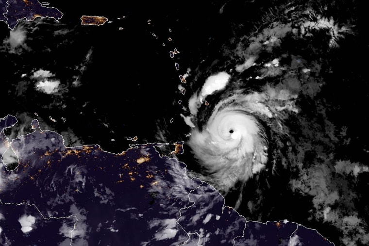
Hurricane Beryl made landfall on Grenada’s Carriacou Island on Monday morning as an extremely dangerous Category 4 storm with 150 miles per hour winds.
Beryl is expected to bring “catastrophic winds and life-threatening storm surge” to the Windward Islands, which include Grenada, St. Vincent and the Grenadine Islands and Martinique, according to the National Hurricane Center. The southern Windward Islands have already been impacted by storm conditions.
“Residents in Grenada, the Grenadine Islands, and Carriacou Island should not leave their shelter as winds will rapidly increase within the eyewall of Beryl,” the National Hurricane Center warned. “Remain in place through the passage of these life-threatening conditions and do not venture out in the eye of the storm.”
Maximum rainfall of up to 10 inches is possible in the Grenadines and up to 6 inches across Barbados. Hurricane warnings were in effect for Barbados, St. Vincent and the Grenadine Islands, Grenada and Tobago. A hurricane watch was issued in Jamaica.
Life-threatening storm surge may raise water levels by 6 to 9 feet near where the center of the Beryl makes landfall in the hurricane warning area, according to the NHC. Large and destructive waves are possible near the coast.
Grenada Prime Minister Dickon Mitchel said there have already been reports of “extensive storm surge,” damage to buildings and loss of electricity in the country.
“And there is the likelihood of even greater damage,” Mitchell said, adding that there have been no reports of casualties or injuries.
Beryl is the first Category 4 hurricane on record to form in the month of June. The hurricane is also the earliest Category 4 on record for the Atlantic hurricane season, beating the previous record of Hurricane Dennis which formed July 8, 2005.
Video shared by UNICEF Eastern Caribbean show storm surge on Barbados’ south coast and strong winds in Saint Lucia. The U.S. Embassy in Barbados reported power outages and flooding in some areas.
Beryl is currently around 35 miles northeast of Grenada, the center said. The hurricane now has maximum sustained winds of 140 miles an hour and is moving westward at 20 miles per hour.
Beryl had been gaining strength last week, intensifying from a tropical depression to a Category 3 hurricane in 42 hours. It became a Category 4 hurricane in 48 hours. According to ClimateCentral.org, hurricanes get stronger at a faster rate due to warm waters brought on by climate change.
Beryl will continue moving westward, across the southeastern and central Caribbean Sea at least until Wednesday, the agency added.
“Potentially catastrophic wind damage is expected where the core of Beryl moves,” it said.

Winds from the hurricane were extending 35 miles outward from the center, while the winds from the tropical storm could extend up to 115 miles. The Grantley Adams International Airport in Barbados recorded gusts up to 45 miles an hour, it added.
Beryl became an “extremely dangerous” Category 4 storm as it approached the Islands early Sunday before leveling off slightly. While the winds had slightly decreased overnight, the center said, “the area of stronger winds has grown, so the hazards of the hurricane are likely to affect a larger area.”
In Barbados, officials began opening emergency shelters Sunday evening, ordering the closure of all businesses by 7 p.m. Its water authority also urged people to store potable water as water lines would be shut out of precaution.
Thousands of people descended upon the Caribbean island to watch the Twenty20 Cricket World Cup final on the weekend. But the worsening weather meant many including the triumphant India team had not been able to leave.
“Some of them have never gone through a storm before,” Prime Minister Mia Mottley said, according to the Associated Press.
Early Monday, the country’s meteorological department said it had recorded gusts up to 64 miles an hour. Marine conditions “continue to deteriorate,” it said in an advisory, adding Beryl’s center was forecast to move about 80 miles south of the island.
U.S. forecasters added said that while Beryl is expected to turn more westward, “it is too soon to discuss what could happen with Beryl if it makes it into the Gulf of Mexico.”
The hurricane is likely to be in the Caribbean Sea for the rest of the week before making landfall on the Yucatán Peninsula as a Category 2 storm. It is expected to weaken to a tropical storm as it moves into the southwestern Gulf of Mexico.


