2024-10-01 05:50:03
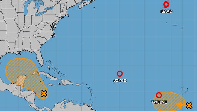
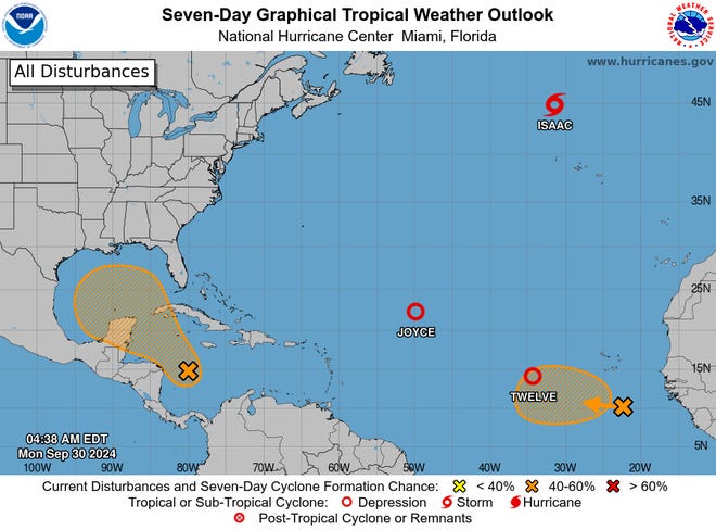
Although forecasters with the National Hurricane Center are tracking five separate systems in the Atlantic Ocean, including newly formed Tropical Storm Kirk, only one is a real concern for the United States and the storm-battered Southeast.
The system most likely to affect the United States was located in the Caribbean Sea, the hurricane center said Monday. A “broad area of low pressure” in the sea is producing disorganized showers and thunderstorms, and environmental conditions appear to be conducive for gradual development of the system.
The center said “a tropical depression could form in a few days while the system is over the southern Gulf of Mexico or northwestern Caribbean Sea.”
The system will be slower to develop than had been thought: “While interests in the northwestern Caribbean Sea and along the U.S. Gulf Coast should continue to monitor the progress of this system, the timetable for potential development has shifted later toward late week or this weekend,” the center said in an advisory Monday morning.
The center says the system has a 40% chance of formation through the next seven days.
AccuWeather forecasters said Monday that perhaps the highest risk for significant and possibly excessive rainfall from the system will be across Florida, but this is subject to change as the system develops.

Atlantic storm tracker
Tropical Depression Joyce, Tropical Storm Isaac continue to weaken
Tropical Depression Joyce was forecast to continue weakening during the next 48 hours, the hurricane center said Monday, and it was likely to become a post-tropical remnant low later Monday and dissipate by Wednesday.
Tropical Storm Isaac was located about 515 miles north-northwest of the Azores on Monday morning, and a turn toward the northwest at a similar forward speed is expected on Tuesday, the center said.
“Slow weakening is expected during the next several days,” the center said Monday morning. Isaac is forecast to become a post-tropical cyclone later Monday.
Kirk expected to become ‘large and powerful’ hurricane later this week
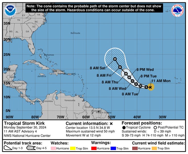
The final storm being tracked by the hurricane center is Tropical Storm Kirk, which formed Monday morning in the eastern Atlantic Ocean.
The hurricane center said Monday morning that a “general westward to west-northwestward motion” is expected to continue through Tuesday, and a gradual turn to the northwest is forecast by Wednesday.

The system has maximum sustained winds near 45 mph with higher gusts, and “steady strengthening is forecast,” according to the center. The storm is likely to become a hurricane by Tuesday night or Wednesday.
Current forecast models show the system curving north into the middle of the Atlantic, well away from the U.S.
Gabe Hauari is a national trending news reporter at USA TODAY. You can follow him on X @GabeHauari or email him at Gd******@*****tt.com.


