2024-09-28 10:10:03
Hurricane Helene strengthened into an “extremely dangerous Category 4 hurricane” before making landfall along Florida’s Gulf Coast late Thursday night, according to the National Hurricane Center.
The storm made landfall about 11:10 p.m. local time near Perry, Florida, about 50 miles southeast of Tallahassee. Helene had sustained winds of abut 140 mph, making it the strongest storm to ever hit Florida’s Big Bend, said Phil Klotzbach, a senior research scientist at Colorado State University.
“Treat these imminent extreme winds as if a tornado was approaching and move immediately to the safe room in your shelter. Take action now to protect your life,” the National Weather Service said.
Widespread power outages were reported as Helene moved ashore, with more than 200,000 without power in Pinellas County late Thursday night.
Officials have issued evacuation orders for residents in several Florida counties including Franklin, Taylor, Liberty and Wakulla, where its joint total population of over 70,000 people have all been ordered to flee.
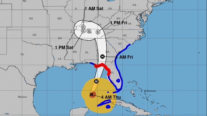
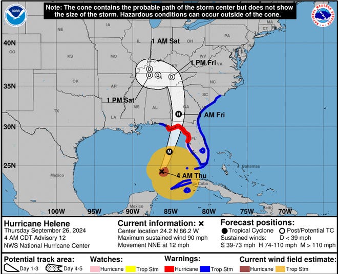
Forecasters expect Helene to head northwestward and slow down over the Tennessee Valley on Friday and Saturday.
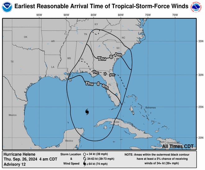
“Weakening is expected after landfall, but Helene’s fast forward speed will allow strong, damaging winds, especially in gusts, to penetrate well inland across the southeastern United States, including over the higher terrain of the southern Appalachians,” the center said in the advisory Thursday morning.
Breaking news every morning: Sign up for USA TODAY’s Daily Briefing newsletter.
Live updates:Helene strengthens to Category 2, closing in on Florida
Storm surge:Hurricane Helene’s ‘catastrophic’ storm surge brings danger, disastrous memories
Hurricane Helene tracker


Hurricane Helene spaghetti models
Illustrations include an array of forecast tools and models, and not all are created equal. The hurricane center uses only the top four or five highest performing models to help make its forecasts.
Helene’s massive size is difficult to digest
Helene is forecast to produce another historic surge, this one along the region where Florida’s coast wraps around the northeast corner of the Gulf of Mexico, often referred to as the “Big Bend.” Throughout the Gulf Coast, but especially here, residents are no stranger to the troubles that flow in with floodwaters.
Warnings ranging as high as 12 feet are in effect elsewhere along almost the entire west coast of Florida, said Jamie Rhome, the center’s deputy director.
“The large size of this storm is going to push so much water,” Rhome said. “When it comes to storm surge the size of the hurricane is more important than the intensity of the storm, which is hard for some people to digest.”
Helene is enormous. Hurricane-force winds extend outward up to 25 miles from the center and tropical storm-force winds extend outward up to 345 miles from the center.
Helene is the fifth hurricane of the 2024 Atlantic season. By late Thursday it will be make it the fifth consecutive year that a major hurricane hits the U.S. mainland, according to Colorado State University hurricane researcher Phil Klotzbach.
News about our planet, in context. Sign up for USA TODAY’s Climate Point newsletter.
How storm surges form:Florida is on storm surge watch as Helene grows stronger: Here’s what that means
Travel impacts:Hurricane Helene delay or cancel your flight? What to expect from your airline.
How does a storm surge happen?
Hurricane and storm surge watches cover much of the Gulf Coast of Florida as Tropical Storm Helene is projected to is projected to strengthen into a major hurricane and move northward from the Caribbean into the Gulf of Mexico.
The sudden rise of water topped by already high and powerful waves could deliver a battering blow that can sweep homes off their foundations and flood low-lying areas miles inland.
In the open ocean, hurricane winds push water toward the center of the storm. Instead of piling up, the water spirals downward and flows outward.
As the water is pushed downward, some is pushed out to sea and some is pushed toward the coast.
As the storm approaches land and shallow water, the ocean floor blocks the outflowing water, causing the ocean to surge onto land.
The ocean floor and shape of the coast can influence the height of storm surge – the difference between water levels when a storm approaches. Along the Gulf of Mexico, wide, gently sloping continental shelves make the coastline more vulnerable to water piling up. On the Atlantic coast, narrower shelves with steep slopes produce a lower surge.
Projected storm surge heights along Gulf Coast
The hurricane center says the following surge height could be possible in locations along these areas of the coast:
- Carrabelle to Suwannee River: 15-20 feet
- Apalachicola to Carrabelle: 10-15 feet
- Indian Pass to Apalachicola: 6-10 feet
- Mexico Beach to Indian Pass: 3-5 feet
- Suwannee River to Chassahowitzka: 10-15 feet
- Chassahowitzka to the Anclote River: 8-12 feet
- Anclote River to Middle of Longboat Key: 5-8 feet
- Tampa Bay: 5-8 feet
- Middle of Longboat Key to Englewood: 4-7 feet
- Englewood to Flamingo: 3-5 feet
- Charlotte Harbor: 3-5 feet
- Florida Keys: 1-3 feet
- Flagler/Volusia County Line to South Santee River, South Carolina: 1-3 feet
Watches and warnings in effect for Florida
Here is a look at the watches and warnings in effect in Florida.
Hurricane Helene livestream
Watch live as Hurricane Helene heads north past Mexico’s Gulf Coast.
This story has been updated with new information
Contributing: John Bacon, Cheryl McCloud, Jeff Burlew, Christopher Cann, Jorge L. Ortiz, Javier Zarracina, Ramon Padilla and Stephen J. Beard, USA TODAY


