2024-08-02 22:40:02
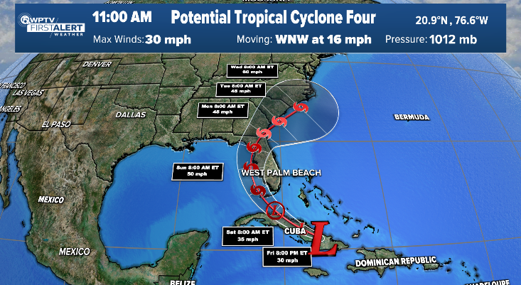
WEST PALM BEACH, Fla. — Potential Tropical Cyclone Four is moving over eastern Cuba Friday and is expected to strengthen into a tropical depression, then Tropical Storm Debby, and bring heavy rain and flooding to South Florida over the weekend.
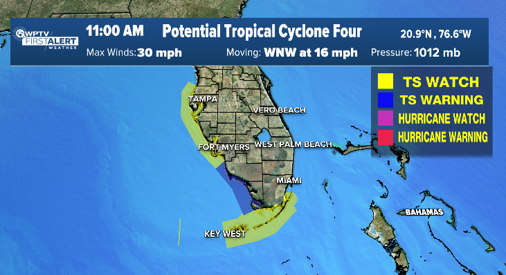
The National Hurricane Center said a tropical storm warning is in effect for parts of Southwest Florida from East Cape Sable — at the tip of the Florida Peninsula — north to Bonita Beach.
In addition, a tropical storm watch is in effect for parts of the Florida Keys and coastal Southwest Florida. Palm Beach County and the Treasure Coast are not under any watches or warnings right now.

WPTV
The NHC said this wave is expected to develop into a tropical depression on Saturday as it moves across the Straits of Florida, followed by intensification into Tropical Storm Debby by Saturday night.
The wave has a 70% chance to develop over the next two days and an 90% chance over the next seven.
It’s expected to move near or over Cuba throughout the day Friday, and then emerge over the Straits of Florida tonight or Saturday, then move near or over the west coast of Florida Saturday night through Sunday night.

WPTV
TRACKING THE TROPICS: Hurricane Center | Hurricane Guide
“Clouds are bubbling up, indicating thunderstorm activity,” WPTV First Alert Weather meteorologist Jennifer Correa said. “But it’s still not confined, tight enough that there’s a center.”
Correa added that environmental conditions are expected to be conducive to additional development, and a tropical depression is likely to form this weekend over the Straits of Florida or eastern Gulf of Mexico near the Florida Peninsula.

Parts of Palm Beach County are under a “slight” risk of excessive rainfall, the second lowest tier, while the rest of our viewing area is under a “marginal” risk, the lowest tier.
“We are under a risk of excessive rainfall. Basically calling for scattered flash flooding,” Correa said. “More than likely, the farther south you are, the heavier or the more accumulated rainfall you’ll get.”
Correa said parts of our area could pick up two to five inches of rainfall over the coming days.
Correa said the rain and storms will start to ramp up late in the morning on Saturday and continue into Sunday, before eventually weakening a bit on Monday.
“These scattered showers and thunderstorms are gonna come in almost in feeder bands,” Correa said.
WATCH: WPTV First Alert Weather forecast
WPTV First Alert Weather forecast, morning of Aug. 2, 2024


