2024-07-02 07:10:02
CNN
—
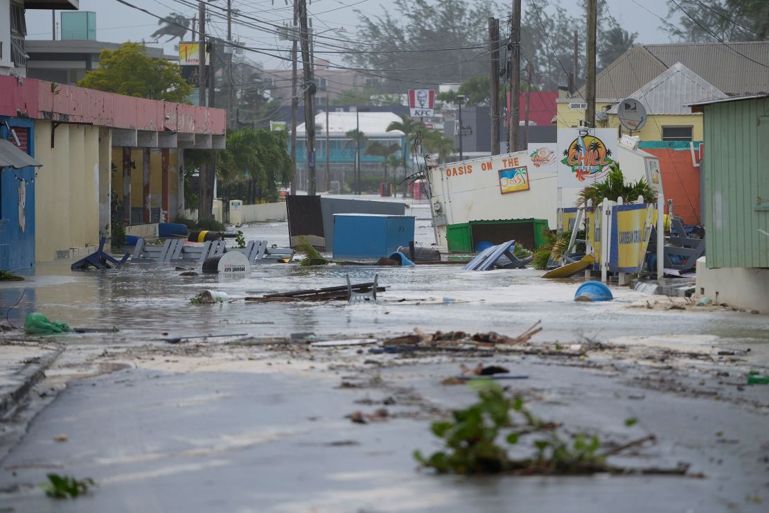
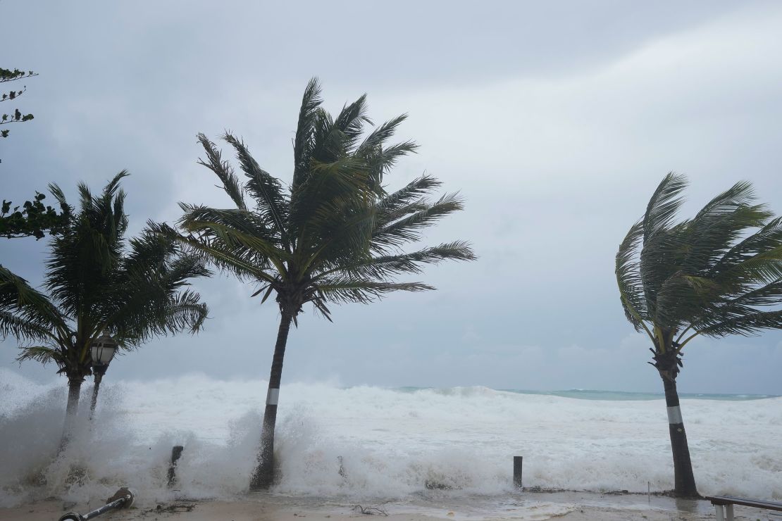
Hurricane Beryl roared across the Windward Islands on Monday as an extremely dangerous Category 4, delivering catastrophic winds, intense rainfall and life-threatening storm surge.
And the storm has become “even stronger as it moves quickly across the southeastern Caribbean,” the National Hurricane Center warned Monday evening, with winds just 2 mph short of a Category 5 hurricane.
“Fluctuations in strength are likely during the next day or so, but Beryl is expected to remain an extremely dangerous major hurricane as its moves over the eastern Caribbean,” the center said.
Beryl made landfall shortly after 11:00 a.m. EDT on Grenada’s Carriacou Island in the Caribbean Sea with max winds of 150 mph. It is the strongest known hurricane to pass through the Grenadines, according to data from NOAA that goes back to 1851.
There were “widespread reports of destruction and devastation in Carriacou and Petite Martinique,” Grenada Prime Minister Dickon Mitchell said in a Monday news briefing. “In half an hour, Carriacou was flattened.”
Mitchell said there were no immediate reports of death or injury but warned that could change.
“You have to appreciate the ferocity and the strength of the hurricane and therefore we are not yet out of the woods,” he said. “And we are not able to say for sure that no one has been injured or there has been no loss of life as a result of the hurricane.”
The storm knocked out power across the island chain. About 95% of the island of Grenada has lost power due to Hurricane Beryl, Neila K. Ettienne, press secretary for the office of the prime minister, told CNN on Monday. Telecommunications across Grenada are down, and some individuals have lost internet service, Ettienne explained.
All schools and business are closed, including the airport, the secretary said, adding only hospitals and the national police force are currently operational. The airport reported a sustained wind speed of 92 mph and a gust of 121 mph Monday afternoon, according to the National Hurricane Center.
Beryl’s arrival marks an exceptionally early start to the Atlantic hurricane season. On Sunday it became the earliest Category 4 on record in the Atlantic Ocean and the only Category 4 in the month of June. The abnormally warm ocean waters that facilitated Beryl’s alarming strengthening are a clear indicator that this hurricane season will be far from normal in a world warming due to fossil fuel pollution.
Beryl is breaking records for June because the ocean is as warm now as it would normally be at the peak of hurricane season, said Jim Kossin, a hurricane expert and science advisor at nonprofit First Street Foundation.
“Hurricanes don’t know what month it is, they only know what their ambient environment is,” Kossin told CNN. “Beryl is breaking records for the month of June because Beryl thinks it’s September.”
Kossin added the ocean heat fueling Beryl’s unprecedented strengthening “certainly have a human fingerprint on them.”
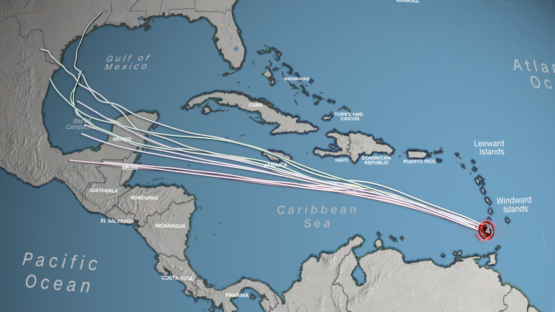
• Beryl is a dangerous hurricane: The storm was located 575 miles east-southeast of Isla Beata in the Dominican Republic, had sustained winds of 155 mph and was moving to the west-northwest at 21 mph as of Monday evening. Beryl’s hurricane-force winds extend 40 miles from center while tropical-storm-force winds extend about 125 miles. The storm’s center is expected to move away from the southern Windward Islands Monday night and across the southeastern and central Caribbean Sea through Tuesday, and is forecast to pass near Jamaica on Wednesday.
• Life-threatening storm surge and flooding: The National Hurricane Center warned “life-threatening storm surge will raise water levels by as much as 6 to 9 feet above normal tide levels in areas of onshore winds near where the eye makes landfall in the hurricane warning area.” The center also noted large swells from the storm will continue in the Windward and southern Leeward Islands for the next couple of days. “Swells are also expected to reach the southern coasts of Puerto Rico and Hispaniola late tonight into Tuesday. These swells are expected to cause life-threatening surf and rip current conditions,” it said.
• Hurricane warning: In effect for Jamaica, with hurricane conditions possible by Wednesday. Tropical storm warnings are in effect for the south coast of Dominican Republic from Punta Palenque westward to the border with Haiti, and the south coast of Haiti from the border with the Dominican Republic to Anse-d’Hainault.
• Hundreds evacuated: More than 400 people were being housed in hurricane shelters across Barbados on Sunday night, the nation’s Chief Shelter Warden, Ramona Archer-Bradshaw, told CNN affiliate CBC News.


• State of emergency in Grenada: A state of emergency declared Sunday night by Grenadian Gov. General Cécile La Grenade will remain in effect until Tuesday morning. All businesses have closed except the police force, hospitals, prisons, waste disposal and ports.
• Airports remain closed: Airports in Barbados, Grenada and Saint Lucia were closed Sunday night as Beryl approached. Grenada’s Maurice Bishop International Airport is expected to reopen Tuesday morning, a spokesperson said. The Grantley Adams International Airport in Barbados and St. Lucia’s Hewanorra International and George Charles airports have also halted operations.
• Cricket World Cup fans stuck: Barbados is still hosting cricket fans from around the globe who traveled to the island for the T20 World Cup, some of whom are not scheduled to leave until Monday or Tuesday, said Barbados Prime Minister Mia Amor Mottley. “Some of them have never gone through a hurricane or a storm before,” she added, imploring residents to provide support for visitors, if possible.
Landfall is far from the end of Beryl’s story, and its long-term path is still uncertain.
The hurricane will track generally west or northwest over the Caribbean Sea through Thursday, and is expected to remain a major hurricane – Category 3 or stronger – into midweek before losing a bit of strength.
Even so, the hurricane will remain formidable with strong winds, torrential rain and hazardous seas extending well beyond its center over much of the Caribbean. Beryl’s center could pass just south of Jamaica on Wednesday and bring heavier impacts to the country even if it doesn’t make landfall there.
“Storm surge could raise water levels by as much as 2 to 4 feet above normal tide levels in areas of onshore winds along the immediate coast of Jamaica,” the hurricane center said.

Several days are likely to elapse between Beryl’s first landfall in the Windward Islands Monday and its next likely landfall on or around Mexico’s Yucatan Peninsula around Friday morning.
What happens after Beryl’s next landfall will also determine if the cyclone is able to reach the Gulf of Mexico over the weekend. If Beryl is able to survive its journey over land and reach the bathtub-warm waters of the Gulf of Mexico, it could spell trouble for northeast Mexico or possibly the US Gulf Coast.
This season is already off to a busy start as a second storm – Tropical Storm Chris – made landfall near Tuxpan, Mexico, off the Gulf Coast early Monday.
Beryl is ushering in a troubling start to a hurricane season that forecasters have warned will be hyperactive – and Beryl’s record-shattering activity may be a sign of what’s to come.
Beryl is the earliest major hurricane – defined as one that is Category 3 or higher – in the Atlantic in 58 years. The storm’s rapid intensification is very atypical this early into hurricane season, according to National Hurricane Center Director Mike Brennan. It’s rare for tropical systems to form in the central Atlantic east of the Lesser Antilles in June, particularly strong ones, as only a handful of tropical systems have done so, according to NOAA records.
The storm isn’t just early for this season. It is now the Atlantic Ocean’s third-earliest major hurricane. The earliest was Hurricane Alma on June 8, 1966, followed by Hurricane Audrey, which reached major hurricane status on June 27, 1957.
Beryl has also set the record for the easternmost hurricane to form in the Tropical Atlantic in June, beating a previous record set in 1933.
If Beryl should become a Category 5, it would be the second time an Atlantic hurricane reached this strength in July, following Emily in 2005 — and the earliest Category 5 storm on record.
The central and eastern Atlantic traditionally become more active in August, in part because ocean temperatures have had time to warm and fuel developing systems.
This year, however, the Atlantic basin has seen above normal water temperatures and a lack of wind shear due to the transition from El Niño season to La Niña season, both of which are fuel for tropical development.
“Beryl has found an environment with very warm ocean waters for this time of year,” Brennan said.
Systems forming this early in the summer in this part of the Atlantic is a sign of the hyperactive hurricane season to come, according to research from Phil Klotzbach, a hurricane expert and research scientist at Colorado State University. Normally, ocean temperatures aren’t warm enough in June and July to help tropical systems thrive.
National Weather Service forecasters predict 17 to 25 named storms this season, with as many as 13 of those becoming hurricanes.
“That’s well above average,” Brennan noted.
CNN’s Zoe Sottile, Monica Garrett, Gene Norman, Michael Rios, Marlon Sorto, Sandi Sidhu, Melissa Alonso, Isaac Yee, Eric Zerkel, Rachel Ramirez and Brandon Miller contributed to this report.


